Microwave Rainscatter in the Upper Midwest
By
Mike A. King – KMØT
Original Article Published in CQ-VHF
Winter of 2005 Issue
See the CQ-VHF Website for Subscription Information
Introduction:
I had spent a number of months on the microwave bands, without knowing that a very promising method of propagation existed. Through multiple contests and chasing rover NØDQS, it became apparent that 5.7 and 10 GHz were enhanced when we had rain in the area.
I wondered a bit about this and began to do some research on this particular propagation mode. With what I found, it was pretty much apparent that the guys in Europe probably laugh at us when we post our rain scatter attempts and accomplishments, because this is a lot of their “bread and butter” propagation. There are some good articles from the European guys on this mode and also from WA1MBA on 10 GHz rain scatter.
Rain scatter is not a hard thing to accomplish, in fact I was working it without really knowing it, and now lots of the folks around the NLRS (Northern Lights Radio Society) area are “in tune” with this predictable propagation mode and are taking advantage of the potential it offers.
Working the mode without knowing!
Chasing NØDQS was one of my main efforts during the major contests. During 2002 UHF, contest, I recall having great signals on 5.7 and 10 Ghz without any explanation of why the standard forward scatter tropo was better than it was just shortly before. I however made it a priority to watch the local radar for Gene, just to help keep him out of trouble from storms and such.
Gene – NØDQS/R in the thick of it during the 2002 UHF Contest
The particular grid he was in was not that far away, but signals were somewhat “auroral” on SSB and the radar confirmed that there was rain in the area. Gene in fact had minor squalls of rain all around him while he was in that area, but not around my home QTH. Signals were generally much stronger and we chalked it up to just “dumb luck”. I suppose this was based on observation of signal levels in the earlier parts in the day, where things were dry and signals were in the noise. At that time we were just utilizing brute force forward scatter at 100+ miles. We always knew we could work these paths as long as we had the dish antennas pointed properly. But with rain in the area, we had an easy time of it.
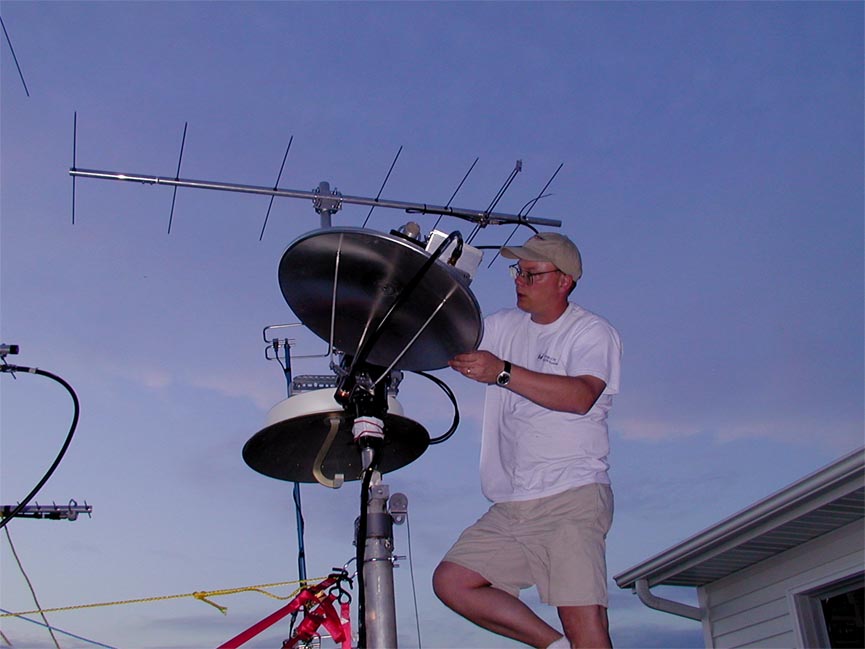
KMØT helping NØDQS/R with final installation of the microwave dishes prior to the 2002 UHF Contest
The nail in the coffin was when Gene, NØDQS took a grid expedition on June 28th of 2003 to Wisconsin so I could pick up that state for the CSVHF Society “States Above 50 Mhz” contest. We were considering brute force forward scatter or a bit of tropo enhancement to do our work. Gene was going to operate portable in EN42nx, the SW corner of Wisconsin.
How it turned out though was much different. I needed Wisconsin on 3.4, 5.7 and 10 GHz, so he had all those bands along. We found each other on 5.7 and 10 GHz on the direct path, but were having difficulty on 3.4 GHz. We were both running good power, antennas and utilizing superflex hardline feedlines, so we were disappointed when we were not able to make the path. The band simply was not open. My beam heading was very close to 90 degrees, due east, while Genes was 270 due west.
With a bit of pointing around however, I began to hear Gene, albeit weakly, and we managed to work with fairly strong signals. Again, the “auroral” sounding CW/SSB was present.
A quick look at the weather map indicated that rain was present just to the north of the direct path. Gene indicated that he was hearing me pretty well when he pointed nearly 20 degrees north of the direct path. With that, I nudged my antennas a bit to the north and he indicated that it made the signals even better. It was about that time that Gene noticed he could see some black clouds off in the distance to his northwest. As it turned out, I ended up being pointed at 82 degrees while Gene was pointed at 315 degrees. He was nearly 45 degrees off of direct heading! We ended up chatting on SSB with 5x3 to 5x4 signals.
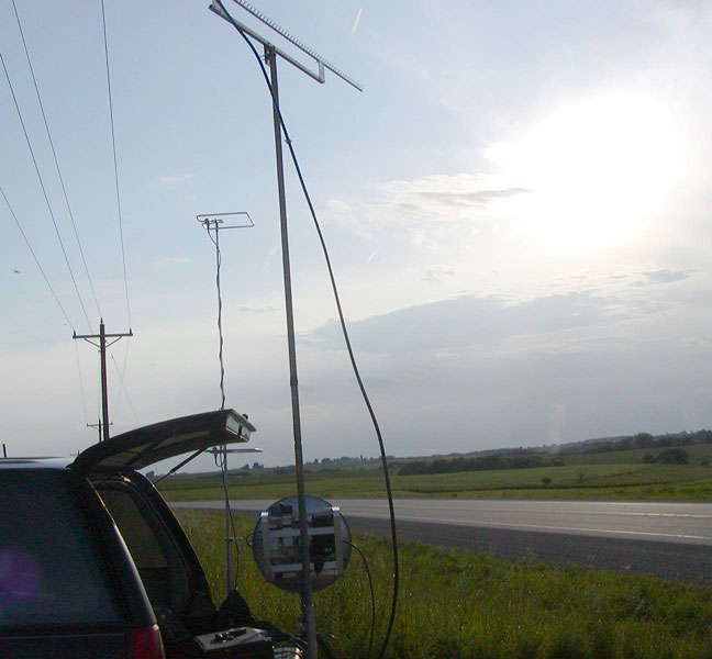
NØDQS operating portable from Wisconsin – EN42nx. Note direct heading for the dish and skew path to the north for the 3.4 GHz looper antenna. One can see the minor precipitation clouds in the distance.
That information led me to quickly check the local radar map on the Internet. It was evident that rain scatter was the reason for the contact. Going back to direct path resulted in no signals heard.
We did not know it at the time, but a distance record for 3.4 GHz rain scatter had never been recorded for the band, so we submitted that later to get a spot on the DX record page! The direct path distance of the contact was 435 km – 270 miles.
We never thought to point the 5.7 and 10 GHz dishes on that path. If we had, the signals could have been much better. But I had Wisconsin in the book and that’s what mattered at the time.
A bit of thinking about all this led to reading the article on rain scatter communications by WA1MBA and asking some questions on the NLRS reflector. The folks in the know indicated that it was very possible that rain had enhanced our paths and that it was something that was pretty common.
Starting to get into the mindset.
So, in that summer of 2003, we began to give it some thought on taking advantage of the rain. When Gene would head out, instead of hoping that the weather was warm and sunny, we were hoping that something would brew up in terms of rain or storms.
Other folks in the NLRS were starting to “tune in” to the mode as well that summer. On June 10th, there were some good storms in EN34, the Minneapolis-St. Paul area. I don’t recall exactly how I knew the guys up there were on, but someone let me know or I read it on the NLRS reflector. But it was like a 10 GHz DX opening!
I first worked Gary - WØGHZ in EN34lx with 5x4 signals, then worked Bob – WØAUS in EN35ka, and Bruce – W9FZ also in EN34. Bruce was on his balcony from his apartment building! All 10 GHz contacts were worked on FM, as the Doppler shift from this particularly intense storm was quite extensive. The Doppler shift in this case was too great as it really made SSB signals unintelligible. CW would have been just fine, we just did not need it to make the contacts. The signals were really good with just a bit of noise and flutter on FM. The typical beam heading to that area is in the 45 to 50 degree range, however I was pointed at 35 degrees and the direct path was roughly 325 km – 200 miles. I then worked Gary – WØGHZ on 5.7 GHz using SSB. Signal here were not as distorted, as the reduction to the lower frequency was not affected as much by the Doppler shift.
Shortly thereafter on July 15th, Bruce – W9FZ made a visit to his folk’s farm in Wisconsin, EN43tq. The direct path heading was 80 degrees and about 475 km – 295 miles. We were wondering again if the standard tropo forward scatter would be good enough to make a contact, but we were again blessed with some thunderheads and general rain in the midpoint of the area. I ended up being pointed in the 95 degree region, but Bruce was pretty much on direct path. However, direct path lineup on each end resulted in no signals heard. Signals were again “auroral” in nature and SSB strength was 5x5 on both sides. It was a very easy contact and a new grid on 10 GHz for me!
Now folks were really fired up about the rain scatter contacts being made in the area. Lots of talk about how “next year” would be when we would really make it happen. However, there were some interesting things still in store for 2003.
I had recently finished my 24 GHz dish project and Gene-NØDQS and I were using them to experiment with DX and learn the propagation as best we could. On the night of August 26th, I noticed a storm cell that was fairly strong to my southeast. A look at the radar showed that Gene was not in the cell, and was due south of the cell in his home QTH in EN22ge. So both of us were outside of the storm and not to worried about getting wet.
A quick scramble to a road map, and using a protractor to somewhat interpret the county lines from the radar over to the road map gave me a rough location of where I thought a scattering point might be. The use of the protractor with the map then gave me a beam heading. For Gene, the storm was pretty much due north. We could both see the lightning flashes in the distance from our particular viewpoint.
It was nice for me, as I had a pretty decent heading through the southeast part of town, so I just set the dish up on my back patio. Gene had to head out just north of Schleswig, Iowa in order to get away from the local clutter.
We had worked the direct path many times on 24 GHz, as we are only 119 km – 74 miles apart. The heading to Gene was typically 149 degrees with his heading being typically 329 degrees.
We started out pointed at the presumed scattering point, about 130 to 135 degrees for me, while he was pointed basically north at the flashes in the distance. We went back and forth for half of an hour with nothing heard at all. I also went back periodically to the computer radar map to see if things were moving out of path. Both of us tuned around and made slight variations in the azimuth plane. We then decided to elevate the dishes slightly to see what may happen then. Within just a few minutes, I heard Gene’s “auroral” sounding CW beacon. In a burst of excitement, I called Gene on his cell phone so he would not move the dish! He then peaked up on me and we had very good signals on SSB! Over a half-hours time, we experimented with the elevation and azimuth on both sides. We chatted quite a bit and also realized that the Doppler shift did not really make the SSB unintelligible, but it definitely shifted the frequency, so we had to use the RIT to keep in adjustment. The shift experienced was a solid 1 kHz.
We did not have a good way to measure elevation at the time, as our bubble levels were maxed out, but I would guess the elevation was in the 5 to 10 degree range. We both took pictures of the dishes from side view to note the level of elevation. It was a really neat contact and doing it at night with the flashes in the distance made it quite exhilarating. My final azimuth heading was about 135 degrees, about 15 degrees off of true heading. Gene was still pointed pretty much due north to the storm. So there was quite the scattering angle!
I got around to posting the information on the NLRS reflector and Jon, WØZQ indicated that there was not a record posted for 24 Ghz rainscatter. So I sent that down to Al Ward – W5LUA and he added it to the list!
Rainscatter in Contests:
Other notable rainscatter contacts came during the second weekend of the ARRL 2003 10 Ghz Contest. The first day of the contest was pretty dry and propagation was not all that great. However, the next morning some interesting things happened. A small amount of rain was present on that Sunday morning and the radar indicated that it was between the EN34 twin cities area and down here in NW Iowa. I managed to catch some fellows on liaison frequencies and started calling up to the EN34 area.
On direct heading, I managed to work KT8O, Eric in EN34. Eric was using and old homebrew very low power transverter on 10 GHz with 432 Mhz IF and DSS dish. Power output was approximately 20 mw. A bit of beaconing on my part enabled Eric to find me and we worked with fairly comfortable signals on SSB. I was then able to work Chris – NØUK and Gary – WØLJC on SSB. Signals were fluttery in quality although stable in strength. The rain was causing just enough forward scatter enhancement to make these 300 km - 180 mile plus paths. Eric, up on the roof of his apartment building in the middle of the cities, was able to contact me on and off to help get me in touch with the other guys on 10 GHz. Who says 10 GHz liaison does not work?
5.7 and 10 GHz dishes at KMØT – pointed at EN34 with a bit of elevation
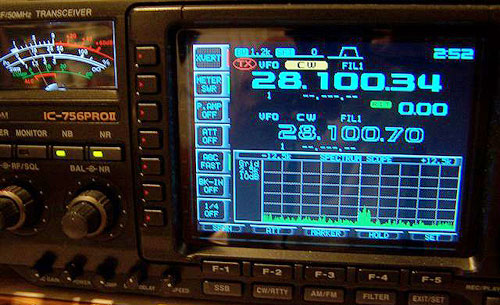
I then decided to just call CQ up there as I knew there may be others on that morning. Sure enough, Gary – WØGHZ came back and we worked on CW. I kept calling and I heard a blip of something, but it was gone right away. I looked up at the band scope on the 756 Pro-II (Which is part of the IF setup) and saw a signal quickly moving down in frequency. I tuned down to where it appeared to stabilize and there was Bob, WØAUS in EN35! Bob had just heard the news and ran outside to set up his portable dish and had just turned it on, so he was really drifting! We ended up having a nice chat there on 10 GHz from his lakefront area, which normally would be pretty much impossible since the elevation is very low.
Bob and I attempted as well to try 5.7 Ghz from his location, but the rain turned off and all the excitement was done for the day!
Basic Theory Behind it:
From what I gather from WA1MBA - Tom’s article on this propagation mode, rainscatter is not a reflection, but really a “re-radiation” of energy. When signals reach the rain droplets of proper size in terms of wavelength comparison, then that particular droplet will “re-radiate” it’s energy to the next, and then the next. This is very simplistic in terms and explanation and there is a great more behind it, but it does work! Check out Tom’s entire article, see http://www.wa1mba.org/10grain.htm
Jon, WØZQ has always been good at watching propagation conditions. Early on the morning of July 29th – 2003, Jon posted to the NLRS reflector that the weather was looking good (or bad, depends on what your up too!) for a possible shot later on in the day to Barry, VE4MA up in Winnipeg, EN19lu. Jon indicated that strong storms were supposed to line well west and north of Minneapolis as they traveled from west to east. At least that was the prediction and he was not to be proved wrong!
Barry got the note and indicated he had a few housekeeping things to take care of with his tower mounted 10 GHz system, but would be ready if the events panned out.
Around 6:00PM, Jon posted again that the storms were “looking good” and was “crammin down dinner” and heading out. He was going to a location near Burnsville, MN – EN34is - which had a great horizon to the NW. Jon stated that he would listen on the odd minutes and send some 10 Ghz beacon RF on the even minutes while he was pointed about 333 degrees, basically on direct path.
Well, Jon did not have any time to send any beacon RF. When he arrived at the site and turned on his dish / transverter, there was a long winded CW CQ being heard. The signal was 5x9+ and went on for a minute. Jon figured it was a local that had seen the postings earlier and was CW beaconing and fishing for QSOs. When the CQ ended and was signed by VE4MA, Jon about fell over!
They quickly got hold of one another and completed the QSO around 6:50PM. Jon had 5x5 to 5x7 signals while Barry signal to Jon was 5x9. Signals were “auroral” sounding in nature and not completely distorted. Jon said that SSB and FM was very probable, they just did not get around to trying. Heading was pretty much direct path. Jon heard Barry’s signal for the next 30 minutes until it faded away. Barry indicated that he heard Gary – WØGHZ and was sending a 5x6 report, but never got the report back on his end.
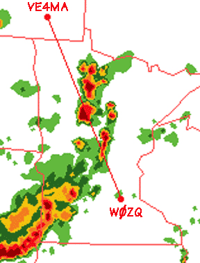
Direct path of WØZQ to VE4MA – note strong cell at midpoint.
The contact between Jon and Barry ended up being about 393 miles – 632 Km. This was good enough to be the 4th farthest rain scatter contact in the continental U.S. on 10 GHz. Jon was running 1 watt into a 22” offset portable dish setup while Barry was running 50 watts via elliptical waveguide to an 18” offset feed dish.
On April 18th - 2004, there was a good storm brewing up by Minneapolis and St Paul. Some cells were lined up from Duluth to the slight NE and SW of the twin city area. It was raining on and off down here with lots of wind and some storms were moving into the area.
I had just got done “buttoning-down” the station, disconnecting cables, etc. when I happened to check the NLRS reflector. Gary – WØGHZ had a simple message: “WORKING KØAWU RIGHT NOW S9++ ON 10GHZ”. I sat there for a minute wondering what I should do. With the wind blowing and storms in the area, I knew I would not have much time as I don’t like being connected when there is lightning around!
I ran downstairs and fired up the IF rigs and transverters on the tower and spun the dishes to about 40 degrees. I then started to elevate the dishes to horizon and began to see radar blips on the 756 Pro-II band scope! A quick listen after a minor peaking of antennas had KØAWU calling NØUKon CW. Bill was 5x5, real good “auroral” sounding signals but with quite a bit of fading. The fading could easily be attributed to my dishes being bounced around by the 35+ MPH winds we were having, which makes the crank-up tubular tower bounce around quite dramatically.
I waited for about two minutes as Bill made repeated calls to Chris – NØUK, but it was apparent that he was not being heard at that time. I could not wait any more so I started calling Bill. After two calls he came back to me and we exchange reports! I would imagine that Bill was quite surprised not knowing I was even going to give him a try! Signals on his side were 5x9 and Bill worked 4 other stations as well. It was a good distance for non-coordinated rainscatter and a new grid! I quickly shut everything down, disconnected cables and went about my normal everyday business of chasing the kids.
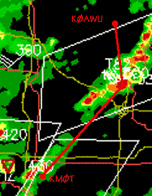
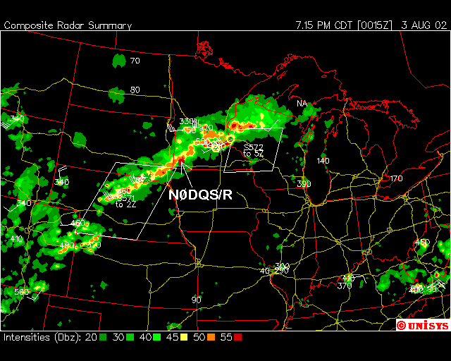
Unisys Radar Image – KMØT to KØAWU
The distance was approximately 493 km – 306 miles and was about 15 degrees off of direct heading from my side. Bill indicated later that I peaked about 10 degrees east of direct, which would make sense. I did not notice much Doppler shift on his signal but we never tried any voice modes, elevation was not a factor as both of us had the dishes level at zero degrees.
Gary – WØGHZ and Steve – N4PZ had been attempting to work on 5.7 GHz via tropo for some time. Steve had just put up a large 7.5 foot dish with 10 watts on 5.7 GHz and had been working some folks recently.
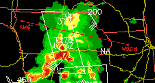
On May 5th, 2004, there was a very good storm system between the two and Gary got hold of Steve for an attempt. They worked in the evening around 0310 UTC on 5.7 GHz with 5x9 signals and followed that up with a contact on 10 GHz, also 5x9 signals both ways. All modes were used, CW, FM and SSB. This was a forward scatter direct path rain scatter contact, so the Doppler shift was not too bad, as SSB was very intelligible and the CW had a typical “auroral” sound. N4PZ was located in EN52gb which gave a distance of 269 miles – 434 Km to Gary’s QTH of EN34LX. Gary runs a 4’ dish on 5.7 GHz with 20 watts and waveguide feed from the shack, while he runs an 18” DSS dish with the transverter and 2 watts at the feedpoint for 10 GHz.
Paths for WØGHZ to N4PZ and W9ZIH
Right after that, N4PZ contacted Ron – W9ZIH in EN51NV in order for him to get on the air. Gary and Ron were able to work on both 5.7 and 10 GHz with little effort. Gary gave Ron 5x3 signals on 5.7 GHz and 5x8 signals on 10 GHz. WØGHZ’s contact times with W9ZIH were about 15 to 20 minutes later than the QSOs with N4PZ, so the rainscatter conditions lasted for quite some time. Also, the distance was extended a bit for the contacts with Ron, 298 miles – 480 Km, which are good hauls on the microwave bands for sure! The path was essentially the same with both N4PZ and W9ZIH, only a few degrees different and posed no pointing issues with the large thunderheads in-between.
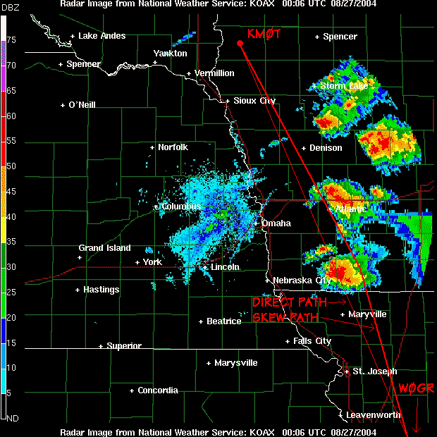
On May 24th, 2004 – I noticed that some light rain with some “good yellow” was showing up on radar around central to eastern Iowa. I was looking like it may be the right spot for a try with Ron – W9ZIH in EN51nv. I gave Ron a quick phone call to see if he could get on and he had some time to give it a shot.
I got his direct heading and the dishes lined up as we went with 2 meter liaison on 144.260 MHz. The storm was a fairly thin line of precipitation that ran from slightly SW to NE. The precipitation being indicated that was crossing the direct path was pretty thin as it was showing just normal to light rain with more intense cells just above and below the direct path.
We started out on 5.7 GHz and made short work of the contact. Signals were 519 with no distortion. We followed that up on 10 GHz with 559 signals on CW and also chatted there on SSB, albeit a bit weak. Again, no distortion was noted, but a slight watery sound was present on both bands and might have been caused by a bit of multi-path. Ron and I discussed this for minute afterwards on 2 meters, then decided to go back to 10 Ghz. He heard me call and fade out; the path had dropped out that quickly.
It appeared to me that the direct path showing just rain, in conjunction with no distortion except some multi-path warble, that the rain was just enough and close enough to the midpoint between us to simply give the signal a boost. It was evident that without the rain, nothing would have happened.
Unisys Radar Image for direct path of KMØT to W9ZIH
Ron’s QTH in Illinois is EN51nv, for a path distance of 382 miles – 615 km. This was another new grid on both bands. Oh, I was informed later by Jon – WØZQ as he looked over my report on the NLRS reflector that the 5.7 Ghz contact was good enough for the USA Continental rainscatter record! Cool!
KMØT and WØGR
Garth – WØGR and I had been trying to work on 5.7 and 10 Ghz for some time over the last few years. We got into a brief tropo opening on August 3rd, 2004 and managed to work on 5.7 Ghz, but were not able to make it on 10 Ghz. A few weeks later, on the 27th, some good storms came to pass. The storms were pretty large, kind of weird for that late in the season but I called Garth on the phone to see if he wanted to give it a shot.
The cell was large and wide, and right smack dab at the midpoint of the path, so it looked very good. There was also opportunity on each side of direct, but going head on seemed to be the place to start. We started there for 25 minutes or so, beaconing back and forth for five minute at a time, but nothing was heard. This seemed odd as the distance was not all that great and the storm looked to be perfect for what we were trying.
With that, I began to swing around a bit and also bumped the dish elevation. This is when I found Garth and gave him a quick call on 432 Mhz as that is where we were doing the coordination. I asked him to keep the beacon going as I was trying to get the signal peaked.
It turned out that the peak was on the east side of the storm, with about 3 to 5 degrees of elevation. No signals were heard with the dish on horizon. When peaked, the signals were extremely weak and distorted. This was much unexpected and took some time to get hooked up. As it was a 50-50 chance, after trying the direct path for some time, the next period of operating was trying to the west of the cell. Lots of time was spent there with no success. After that, signals were found on the east side of the direct path. So one never really knows what will work out! So guessing correctly can save some time!
NOAA Radar Image saved from “RainScatter” – Paths shown by KMØT edits
The distance to WØGR – EM38AX – 308 miles – 495 Km. Signals 5-0 to 5-1 with extreme distortion, so CW was the only mode we could use. Direct path was 156 degrees for me, but the actual skewed path that was worked was about 143 degrees.
Al – WØPUF in Rapid City, South Dakota had been working on his 10 GHz system for some time and we talked a few times over the last year about trying to work each other on 10 GHz. When he got his system up and running, he let me know and then all we had to do was wait for conditions to pan out.
On July 11, 2004, a really big thunderstorm was present north of the Chamberlin, South Dakota area. I kept an eye on it as it was not really at the mid point, but I figured it was worth a try, so I got Al on the phone and he headed out from the home QTH as he needs to operate in portable mode.
After spending a little bit of time beaconing back and forth, I decided to try pointing a bit north of direct path. I found Al at about 298 degrees, where the direct path would have been 283. He was fairly weak, but I was able to copy fine on CW. The signal was hashed up and “auroral” in nature as expected. When Al stopped beaconing, I went back to him on CW and we completed the contact.
Right after that we got hold of each other via the cell phone and decided to peak the antennas on one another. I did this after the contact since I did not want to take a chance on losing him altogether if the rain suddenly stopped. We were able to peak the dishes and ended up with 5x5 to 5x9 signals. SSB was readable but pretty weak as FM was also in there but with a lot of noise.
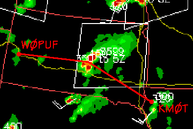
Unisys Radar Image KMØT to WØPUF
Al was running 6 watts from a TWT amplifier and his peaked path was 83 degrees verses 98 degrees for the true path. Al was located in DN84jb and the path distance was 356 mile – 573 km to EN13vc, so it was a pretty good haul. It was a new grid for me and it was Al’s first rain scatter contact and first 10 GHz contact from near his home location!
WØPUF’s signal as it showed up on the 756 Pro II Bandscope
Al kept beaconing for another half and hour or so, as I let both NØDQS and WØGHZ that Al was sending, however nothing was heard by the other stations. Al was strong the whole time here until he decided to give up, so the conditions were very good. Al was not discouraged however as he was really excited about the contact and now knew that Rapid City was on the map for 10 GHz!
More Experiments with 24 GHz Rainscatter:
In late May this summer, I was down in Dennison Iowa (EN22) for a meeting, which
happened to be in Genes - NØDQS's back yard. So I brought along the 24 GHz dish
for some experimenting later that afternoon. Gene and I had been trying some
longer paths on 24 GHz in the recent months, but had little success, so we
wanted to "get close" and test the gear again to see if things were working
correctly. We did a few close paths, just a few miles apart and then at 15
miles. All the equipment was working fine, so we decided to get further apart.
The next spot I arrived at was 45 miles away. Gene had his laptop along and
gave me the
heading after I gave him my GPS 6-digit grid square. I then used KVH Datascope
to get a landmark in the distance on the correct bearing. Sure enough I had
chosen a bad location, because off in the distance was a knoll with a farm house
and trees. However the heading was right at a telephone pole on the farm
property and I used that landmark to line up the rifle scope that was mounted on
the dish. Gene was right on heading albeit weak, just barely copieable on CW as
the obstructions were most likely messing us up.
We then started to point around for potential rainscatter paths as there were
lots of clouds with possible rain between and all around us. The day had
started off very hot and humid, but it had started to cool off quickly and
slight sprinkles were coming into the area.
24 GHz pointed up towards the rain squall
Gene started by elevating his dish while I was transmitting. He got a definite
peak at 8 degrees above horizon. I then in turn elevated my dish, and I also
peaked his signal at 8 degrees. Signals at that point were S7 to S9 and
“auroral” in nature. The signals were on direct heading but elevated. We
switched to FM and had good communications for about 10 minutes. The rain
squall must have been pretty much centered between us, as neither of us could
see it.
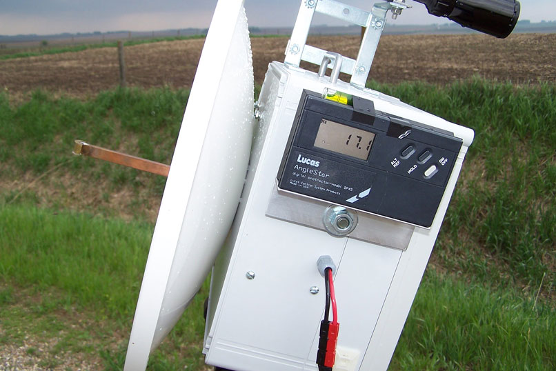
Lucas DP45 AngleStar Digital Protractor showing 17.1 degrees Elevation
We then noticed the signals dropping as whatever was scattering the signals
seemed to be going away or moving out of the path. We re-peaked and the path
appeared to be moving to the east. Elevations were changing too. Over the next
10 minutes or so, the rain squall was continuing to move. At the time of best
signals, I was peaked at 17 degrees above horizon and Gene was at 11 degrees. I
could now see the squall as it was closer to me. The signals then were full
bars on the FT-817 and about 30 degrees off of direct heading. Dropping the
dish to horizon resulted in a total loss of signal so it was definitely rain
scatter. FM was great, SSB on this skew path was completely unreadable. CW was
just like 2M Aurora!
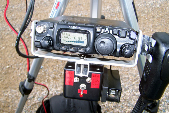
FT-817 – 144 Mhz IF radio – showing full strength rainscatter FM signals at 45 miles
This was not a serious storm at the time, it was just rain and was an excellent
scattering medium. This was also a good test as our first rain scatter on 24
GHz the year before was about 70 miles was a very skewed path. The storm we
were working off then was a serious storm. We had no idea that just general
rain would be good enough to do a contact on 24 GHz. Incidentally, when we did
the 70 mile path, we were at it for over a half an hour with nothing heard.
When we finally decided to elevate the dishes, we found each other in about 5
minutes. We did not have the digital protractors for measuring the elevation at
the time, but I would estimate that is was about 5 to 10 degrees. So what this
confirmed was that elevation for rain scatter on 24 GHz is an important
parameter and should not be discounted when trying contacts via rainscatter.
The conclusions would be that for 24 GHz, general rain is good. SSB will work
on direct path rain scatter, but not skewed paths to a point. And don’t be
afraid to really elevate the dish, it probably make the difference in making a
contact or not!
Low power was used most of the time, switching to high power did little to
improve the signals when we were peaked on one another. This would be from 2.5
watts on the high side to a 1/2 watt on the low side. For a short time, I was
also listening to Gene when I was getting totally rained on, no real apparent
loss of strength, but the signals were pretty garbled! It will take some more
practice, but it seems that longer paths are quite possible.
RainScatter by KØSM:
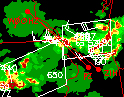
A few of the contacts described in this article were aided by “RainScatter”. This is a Java software application developed by Andy Flowers – KØSM. Andy came up with the idea while reading about all the recent rainscatter contacts being made, and seeing that folks were having a hard time tracking cells and figuring out headings to the scatter points in real time.
Andy’s program simply loads a local NOAA radar map and when you plug in the 6-digit grid square of both stations, it will project a path between the stations and show the midpoint between them. Then, one simply takes the mouse the clicks on the radar map overlay where the cell looks the best for a potential scattering point. With that one click, the program then calculates the beam headings to the scattering point for both stations. The program also gives distances, scattering angle and can automatically update the radar map every few minutes if desired!
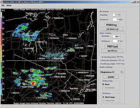
Screenshot from “Rainscatter”
Be sure to check Andy’s website where “RainScatter” is available for download as freeware. Andy’s program has done wonders for helping make rain scatter contacts a normal everyday propagation mode when conditions are there! The link for “RainScatter” is http://mail.rochester.edu/~af006m/RainScatter.html
Closing:
I hope that this article shows folks that rainscatter is a mode worthy of a chance. It doesn’t take much on 10 GHz to take advantage of the mode. With a bit of practice, one can make contacts and pick up grids that were hard to attain via tropo or by being obscured by the local terrain. Get Andy’s program – “Rainscatter” and see what it offers. The rainy season will be back next spring and lots of good DX can be had! 73 and good luck on the bands!
Appendix:
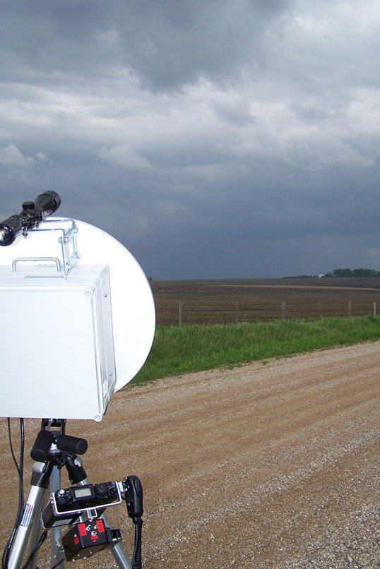
KMØT’s 24 GHz station consists of a portable 48 cm dish with waveguide fed splash feed, waveguide switch and DB6NT transverter. The power amplifier is a solid state 2.5 watt unit and all components are mounted behind the dish in a small enclosure.
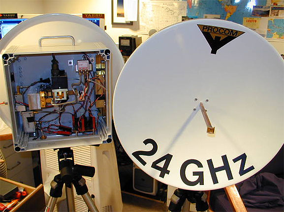
KMØT 24 GHz dishes during final assembly
On the enclosure, a Lucas AngleStar DP45 digital protractor is mounted to indicate the relative elevation of the dish angle. On top of the enclosure, a riflescope is mounted to pick out objects on the horizon for pointing at a specific heading. Heading is determined by using monocle electronic compass, a KVH Datascope. The “Datascope” has a built in electronic compass with monocle viewfinder to pick out objects in the distance and determine their heading. Mariners use these to determine distance and heading while boating or sailing. The “Datascope” has 0.1 degree resolution and can be set for east-west declination based on your location in order to obtain true heading. See the KVH website for details. Note that the “Datascope” is not mounted on the dish, as the metal in the dish and the radio components causes heading errors. All one has to do is to pick out an object on the horizon with the “Datascope” at the correct heading, then look for that object with the rifle scope mounted on the dish! See www.km0t.com for specific details on the 24 GHz equipment and its design layout. 10 grids have been worked to date on 24 GHz from the KMØT rooftop!
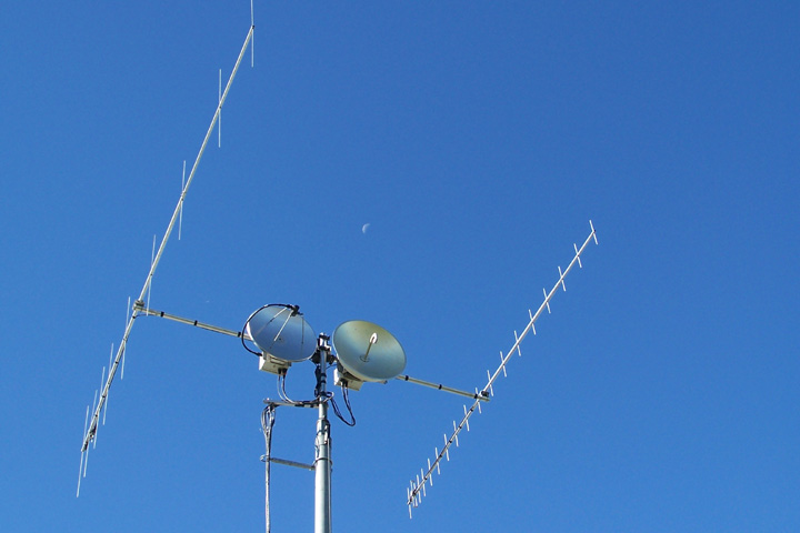
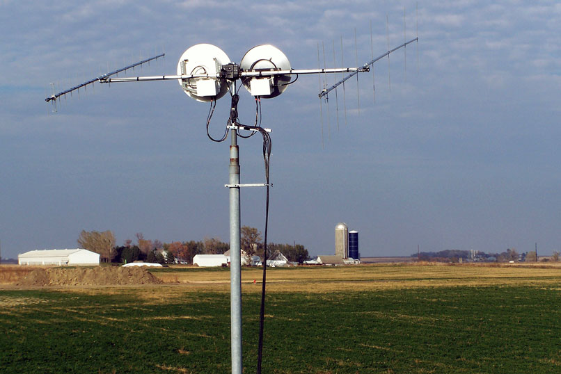
The 5.7 and 10 GHz station at KMØT consists of separate 2’ dishes with DB6NT transverters and DL2AM solid state amplifiers mounted in weatherproof enclosures behind the dishes. The 144 Mhz IF is located in the shack. The dishes are mounted side by side on a horizontal pipe and utilize elevation control with a Yaesu G-500 elevation rotor.
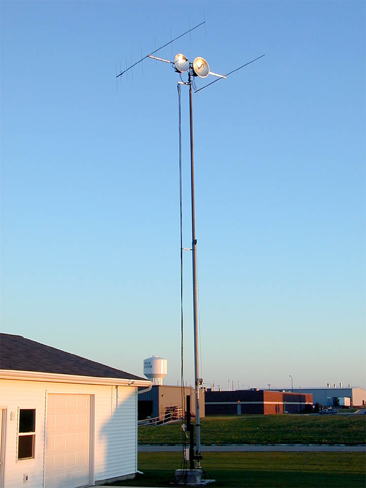
The whole assembly is mounted on a Wilson MA-40 crank-up mast which is rotated from the base by an M2 Orion 2800 rotor. Power on 5.7 and 10 Ghz is over 12 watts each at the feed horns. See www.km0t.com for specific details on the 5.7 and 10 GHz equipment and its design layout. Currently, grids worked on 5.7 GHz is 35 and on 10 GHz is 37.